Troublesome Terrains (and Shaders)
 Garstor
Posts: 1,411
Garstor
Posts: 1,411
Is there a ratio of pixels to distance units in Carrara when you have created a terrain from a heightmap JPG? This seems especially problematic if the size/height of the terrain primitive in altered in Carrara. I find it gets in the way of building a decent terrain shader.
I often use Daylon Graphics' Leveller tool but also frequently tweak things up in Photoshop to create my heightmap. Once I have my Carrara terrain, I use an opaque white plane object that is larger than the terrain so that I can note interesting height values for the Z axis.
What I still find confusing is the Blend feature of the terrain shader. I understand what it is for conceptually, but it is a bugger to find values that work for me without doing a lot of test renders.
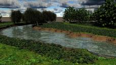
The first image was early in my work on this scene. I have surface replicated stones along the riverbed. The surface of the riverbed and the banked slopes should be looking muddy and brown. But I was getting a lot of "Blend leak" with the grass part of the shader extending far down the bank (a little bit would be nice, but not that much).
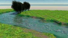
The second image is more or less done -- I'll take what I have learned and go on to make better scenes like this. Although I cured the "Blend leak," my only choice was to remove it entirely; so there is an unnatural hard cut-off between the muddy slope and the grassy plane. One thing I am a bit proud of is combining the replicated rocks with a texture map of sandy gravel that is constrained with altitude to keep it at the river bottom. I think that turned out rather nicely.
Critiques and suggestions for working with terrains and terrain shaders are gratefully welcomed.
Daz 3D is part of 
Connect
DAZ Productions, Inc.
7533 S Center View Ct #4664
West Jordan, UT 84084
Licensing Agreement | Terms of Service | Privacy Policy | EULA
© 2025 Daz Productions Inc. All Rights Reserved.
Comments
sorry can't help you on Terrain - mystery to me too.
For the effect of distance haze you could drop ina few clouds and set them on the terrain. Turn off shadows for them as well.
The bottom pic looks pretty good actually.
Thanks head wax!
Perhaps haze/fog would help to hide the infinite nothingness in the background...I'll give that a shot later today.
I guess as the creator, I tend to be harder on myself critically. The areas without modelled grass were intended to be a concrete/cobblestone pathway. I wanted to decorate that with lamp posts and flowerboxes. Instead...I ended up with a purely nature scene as my ignorances compounded on each other!
That's all part of the fun of playing with Carrara.
Map size divided by terrain size. Simplest maths.
Map size divided by terrain size. Simplest maths.
Does that factor to the changes in height with the greyscale though? Pixel dimensions to terrain dimensions is pretty easy -- let's say 1024x1024 pixels and 500x500 meters would give 2.048. So just over 2 pixels per meter. Coolness.
Would a RGB colour value of (200, 200, 200) versus (198, 198, 198) represent a 1 meter change in elevation? I'm not so sure that translates as well; especially if the height value of the terrain has been modified.
I suppose I'll have to stick to my "debugging plane" solution to find the elevations of certain areas of the terrain. That's not too bad an answer.
A level of 256 would represent the total height set in the terrain editor. So with no other filters switched on if you set the height to 30ft you'll get 30 feet.
You can verifiy this in the motion tab in the assembly room, make sure the scale is at 100%.
To change the scale of the terrain and have the shader autoscaled at the same time, always use the 'rescale terrain to' feature in the terrain editor. You will need to change width and length. Height will scale to match but will not show as changed on the filter. Play with it and see. Again you can check in the movement tab.
Hello Garstor, your river terrain looks quite nice.
I'm using C8 Pro and I usually start with a "medium" size scene scale since I like to incorporate models I've built into my scenes.
When I built this bridge model I also made a simple Terrain profile to match the height of the bridge on the Z axis.
I don't have Leveller(sounds intriguing) so I do an odd workaround. I import the "profile" into Bryce and use the topside camera to make an altitude render. I save the render as a bitmap and import it into the picture section of the terrain editor. Then it is a simple matter to use Bryce's erosion and noise brushes to add natural randomness to my profile terrain.
After that I take the profile bitmap into Photoshop and add a little gaussian blur. If I dont add blur, the terrain will have more terraces than a Burmese rice farm. It would be lovely If I could figure out how to keep the whole process, Bryce>Photoshop>Carrara in 16bit grey-scale domain instead of 8bit. Things would be a lot smoother.
I usually make several different maps from my terrain to use in the surface replicator.
I made a stone map, just as you did here, and I also added several other maps to put some rushes, grasses and other plants near the water's edge. IMO this helps to add some natural looking randomness. I worked hard to make an altitude based river bank shader, but I added so many plants that you can't really make it out anyway, heheh. Keep up the good work. I find this to be a very interesting topic, so I hope others will add their tips and methods. Cheers, Edmund