Terrain height map generator.
 orbital
Posts: 120
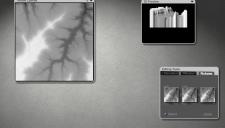
Came across this on a Facebook group post. Basically it will generate any a height map for anywhere in the world. and export it as a png.
In the Terrain editor just load the image and copy and paste before hitting apply.
Also you may want to increase the terrain resolution.
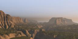
I choose to do a part of the grand canyon, and I must say the result are pretty good.


ex1 copy.jpg
1112 x 632 - 170K


grand canyon.jpg
1200 x 580 - 195K


Comments
Looks interesting. Worth a play
Thanks orbital. Certainly something to try!
Orbital - thank you. Interesting, it's made for a game if I got it right. I've tried a place I know well. The resolution is 60 m/px outside the US and max height difference is 1024 m. This is fine for flat countries but the meager mounds around me are already compressed by a factor of 2.5 and therefore, height resolution is also reduced. The height maps are 16-bit unsigned integer greyscale but the 1024 limit needs only 10 bit. So I get a square of 18 km and can use it in Bryce as 1024 terrain. However, it isn't as bad as I make it appear. It is fast and it's free. I modelled this terrain years ago by drawing the isohypses on a 25,000 map and converted it to greyscale. It took me a week and it wasn't much better. The alternative is using the free 3DEM program and GTOP030 data from Earth (or Mars). So yes, it's quite nice and thanks again for mentioning it. I guess I'll experiment with it a bit more, time permitting.
That's very cool, Orbital...have added it to my Fav file as sure to use it again. Below, did a render of our highest mountain, Carrauntoohil, and the route I took some years back. The resultant height map was overly exagerrated, so reduced it down a bit, but as there are a few small lakes up there too, these would have to be added in individually as they occur at separate heights.
Jay
Jay - nice example. Height maps are often exaggerated in height. Find out how large the ground square is (in metres) and then find the height difference lowest to highest (in metres), then scale the terrain accordingly. Also the Bryce default terrain size with 81.92 square and 20.48 high has the height with a ratio of 4:1 usually exaggerated. My test, which I haven't shown, has a tile size of 18 km and a height difference of 2613 m and I scaled the terrain X and Z 3600 BU and Y 530. I placed the camera to where I am and what I saw in Bryce was what I could see out of the windows - apart from the resolution and the colours.
Cheers, for that, Horo...and I would suspect such a simple interface like this would be great also for the Moon, Mars etc. NASA did have a moon mapper (LMMP) some years back, but they discontinued it for some unknown reason...a pity, as it was super.
I tried a quick test with Ben Nevis and it was passable if a bit smooth
Thanks for sharing, orbital! Looks like a cool thing to experiment with.
I tried a part of a Fjord in Norway. Never been there and don't know the real size. But it looks credible to me! Just had to add some boats (what is that US river boat doing in a Nors Fjord? Being free, I guess!)
Wow, this seems a very nice generator to play with if you know how to use it correctly! The above renders are amazing but mine of Table Mountain not even look like it should. But still a nice way to get mountains even not quite realistic as mine!
I have turned it around in Bryce but can't get a proper look. I have attached some images of the png's after being exported from the terrain height map generator. I have used it as is without doing alterings. I have used the 'merged' png. Am I missing something in Bryce's terrain editor? I am not using terrain editor and learning. Where do I increase terrain resolution?
Any help is much appreciated.
With your terrain selected, click the 'E' icon in the viewport to get to the Terrain editor. Then click the tool circled in the attached screenshot and choose a higher resolution from the context menu (the current resolution will have a checkmark in front of it.) Of course you want to do this BEFORE working with your terrain, not after, so the canvas is already set to higher resolution before you start making changes to it.
I have found that clicking on Normal first and then fine, ultrafine and massive evens out the 'steps' on the final terrain.
Hansmar - very nice fjord scene with the boat.
Launok - nice try. As Fishtales sais, set the resolution first as sriesch shows. 1024 is good since these terrains come as 1081 px square. The real world tile size is 18 km square and the height given in the text file that comes with the files. You have to scale the terrain so that the surface to height ratio matches.
This http://terrain.party/ tool is really nice if you are looking for real terrains. However, it takes a bit of care to make it usable for Bryce. I extracted four tiles and worked for the better part of 2 days to get them together. First problem is to align the selections you save. The second is that if any tile has elevations in excess of 1000 m, the height is squeezed to fit. This results in terraces. And the third issue is that the lowest part is given a height of 60 m. So you don't only have to fiddle to bring the tiles together, but also match the highest and lowest part. Below renders of a 36 x 36 km terrain made from 4 tiles, height from 417 m to 3916 m. Apart from the low resolution and the material applied, it looks as if photographed with a 21 mm lens.
Here is Ben Nevis, highest mountain in the UK, I made it 4000 square and 1400 high which is near the 1340 meters of the real one. I also changed it into a 24 bit .jpg. After loading it into the terrain editor I clicked first on the normal first and then fine, ultrafine and finally massive then added some erosion.
@launok: I have no clue why Table Mountain does not look like a table mountain in Terrain Party. Probably must be the point from which you look at it? But it can also be caused by this: "
The following height maps have some missing data:
* ASTER 30m
* Merged
Locations with missing data are represented by elevation of 0." (see the text file that is also exported)
@Horo: Thanks. Your images are amazing! You can increase the size of the grid up to 60 km in Terrain.party. At the right there is the + and - that increase and decrease the size. 60 km is max and 8 km = min.
@Fishtales: looks very good too.
I made another one, with a big grid. Since the real size was not of interest to me, I did not attempt to get it right. I call it Iceland (it came from there too).
thanks for that link, only saw this thread being in Brycetalk and all, Carrara uses heightmaps too
yes, thanks from here too ;)
Sandy - looking good.
Hansmar - nice Iceland. Thanks for the tip to adjust the scale the part selected.
However, the resolution changes. The square exported has the same size of 1081 px, no matter whether you export a 60 km or a 8 km square. The resolution of the data is always the same: 60 m/px. I tested this out (green 8 km, blue 18 km, red 60 km) and the 8 km doesn't seem to have the better resolution than the 18 km. However, we shouldn't see this too negative. With the 60 km you can add terrain in the distance, partly hidden in the haze and resolution is of no concern anymore.
@Horo: Though I did not test the resolution, I more or less feared something like that already. So, high size for far away only!
Hansmar - it's no problem if you know. Using the setup shown above with the four 16 km tiles and a 60 km tile, I set the camera at 4000 m altitude, about 800 m above a summit (Wildstrubel) and looking south. There should still be more mountains, though.
Horo
Amazing scene
Ok, where are the height maps? I see options for several maps, but they're all pictures or artificial maps, no elevation one?
Sandy - thank you. The rivers, trees and houses are still missing.
sriesch - what you download from http://terrain.party/ are 16-bit PNGs, 4 resolutions, size 1081 px diameter, Bryce TE reads them, and a text file. All neatly zipped together. No meshes, elevation is in the brightness.
Are you looking at this (exhibit A)? You need to click on export (exhibit B)
ah, that was it, thanks!
@Horo: What a very good looking scene. I can imagine that with some woods and a road and houses it is very, very realistic!
Thank you, Hans. Well, the valley floor is about 12 km away from the camera. Houses and woods would have to be very small. With the low resolution, you have to move the camera away. I just checked, I could get 2 m/px resolution GeoTIFFs (64 bit grey) for around $10,000 or more. If I had that much spare money, I'd rather invest it in crowd funding to develop Bryce. But hey, these low-res height maps are free so we live with the limitations.
That or OpenSource it...but you'd probably need more money to buy it out.
And those height maps are very usable at the resolutions they are at. I've been playing around with them in other programs (don't have Bryce installed. currently....need more hard drive space for that). And I've had some pretty nice results on just a subdivided plane in Studio...yeah it's a lot harder to get a good scale on the terrain, but it does work.